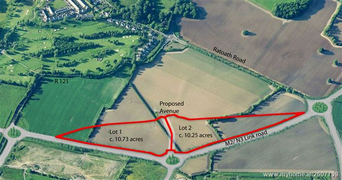
Lands at Hollywoodrath, Hollystown, Dublin 15
Sold
Development Land 20.98 Acres
Description
Development land for sale - 20.98 acres (8.49 hectares).
20.98 Acres Development Land zoned RA under Fingal Co Co Development Plan - LAP Completed
Available in 1 or 2 Lots
The Lands
The lands comprise c. 20.98 acres and are situated at Hollowoodrath, Hollystown, Dublin 15 between the existing built up areas of Blanchardstown to the south and a rural hinterland to the north. The lands, available in one or two Lots, are currently zoned 'RA'and comprise c. 10.73 acres and c. 10.25 acres respectively. They are situated in a prominent position close to Tyrrelstown and adjacent to the new M2/N3 Motorway link road which is now completed.
The lands are strategically located immediately adjacent to the recently constructed M2 / N3 Link Road. The setting enjoys the rural backdrop of Hollystown and rural hinterland to the north. It also benefits from ease of access to the City Centre, Blanchardstown, Dublin Airport and the main arterial routes out of Dublin combining to render this a highly sought after residential area.
The lands are currently under grassland / tillage interspersed with a number of mature hedgerows, and are located outside the Inner Airport Noise Zone. They are traversed by two overhead powerlines and pylon structures.
The road incorporates cycle and pedestrian linkages to Tyrrelstown Local Centre as well as the primary schools and community centre. The lands are accessed immediately off a new roundabout which will form a new avenue road through the lands.
Existing Services and Facilities
There are currently a wide range of existing services and facilities within the immediate area including –
• Two national schools – Tyrrelstown Educated together and St Luke’s National School
• Tyrrelstown Community Centre – opened 2012
• Planning lodged for a secondary school adjoining Tyrrelstown
• An established shopping & local centre at Tyrrelstown
• Blanchardstown Shopping Centre – 4kms
• National Aquatic Centre with Irelands only 50m swimming pool – 3.5kms
• Hollystown 27 hole Golf Course – 1.6 kms
• Blanchardstown IT – 3 kms
• Tyrrelstown Park (currently under construction) – 1km
Zoning
The lands are located within the administrative boundary of Fingal County Council. The Fingal Development Plan 2011 – 2017 provides for the zoning objectives ‘RA’ – Residential Area and ‘LC’ – Local Centre (residential and local retailing facilities ) within the Kilmartin Local Area Plan 2013.
Zoning Objective ‘RA’ – “ to provide for new residential communities in accordance with approved local area plans and subject to the provision of the necessary social and physical infrastructure “
Kilmartin Local Area Plan (LAP) 2013 – sets out a development strategy for the proper Planning and Development of the LAP lands. The LAP RA zoned lands, of which the subject lands are part of, will facilitate approximately 1400 residential units. The RA lands east of the R121 (including the subject lands) will support a density of 20 units per hectare.
A pre-planning discussion with FCC to confirm phasing and densities and to ascertain necessary requirements is recommended.
BER Details
BER:
BER No. XXX
Energy Performance Indicator: XXX kWh/m²/yr
Accommodation
Available in 1 or 2 Lots
Lot 1 - 10.73 Acres
Lot 2 - 10.25 Acres
Viewing Details
By appointment only
